


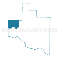
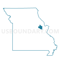
Walnut Grove Voting District, Warren County, Missouri
About
Outline

Summary
| Unique Area Identifier | 611520 |
| Name | Walnut Grove Voting District |
| County | Warren County |
| State | Missouri |
| Area (square miles) | 26.83 |
| Land Area (square miles) | 26.75 |
| Water Area (square miles) | 0.09 |
| % of Land Area | 99.67 |
| % of Water Area | 0.33 |
| Latitude of the Internal Point | 38.80933820 |
| Longtitude of the Internal Point | -91.35466880 |
Maps

Graphs
Select a template below for downloading or customizing gragh for Walnut Grove Voting District, Warren County, Missouri


Neighbors
Neighoring Voting District (by Name) Neighboring Voting District on the Map
- Big Spring/Americus Voting District, Montgomery County, MO
- Gore - Case Voting District, Warren County, MO
- High Hill Voting District, Montgomery County, MO
- Jonesburg Voting District, Montgomery County, MO
- New Florence/Danville Voting District, Montgomery County, MO
- Pendleton Voting District, Warren County, MO
Top 10 Neighboring County Subdivision (by Population) Neighboring County Subdivision on the Map
- North Elkhorn township, Warren County, MO (7,412)
- Bear Creek township, Montgomery County, MO (2,566)
- Danville township, Montgomery County, MO (1,950)
- Loutre township, Montgomery County, MO (1,397)
- Bridgeport township, Warren County, MO (743)
Top 10 Neighboring Unified School District (by Population) Neighboring Unified School District on the Map
- Warren County R-III School District, MO (18,599)
- Montgomery County R-II School District, MO (8,610)
- Gasconade County R-I School District, MO (7,671)
Top 10 Neighboring State Legislative District Lower Chamber (by Population) Neighboring State Legislative District Lower Chamber on the Map
Top 10 Neighboring State Legislative District Upper Chamber (by Population) Neighboring State Legislative District Upper Chamber on the Map
Top 10 Neighboring 111th Congressional District (by Population) Neighboring 111th Congressional District on the Map
Top 10 Neighboring Census Tract (by Population) Neighboring Census Tract on the Map
- Census Tract 8202.02, Warren County, MO (7,508)
- Census Tract 8201.01, Warren County, MO (7,236)
- Census Tract 9703, Montgomery County, MO (3,268)
- Census Tract 9704, Montgomery County, MO (2,528)